Wednesday, March 06, 2013

Mohastan Gor


Mohastan Gor is really an interesting & historical place in Bangladesh.
It is seven miles away from the district town of Bogra. It has the relics of the ancient culture, Mazar, old buildings etc. There runs the river Karotoa nearby. So, it offers very charming sceneries together with the murmuring sound of the Karotoa. There is the Mazar Sharif of Balki Sultan who dedicated his life to the cause of Islam. It was during thereign of king Parsuram. The Sultan came from ‘Balkan’ to preach Islam. It was the order of Allah. He gradually won the heart of the people & defeated Parsuram.
Now, the Mazar Sharif is visited by thousands of Muslims everyday. There are ‘Zeut Kunda’ & ‘the Museum’ in Mohastan Garh. When the soldiers of Parsuram had been killed in the battle field, the king took water from the pucka well & used to give it on the body of the dead soldiers. As a result, they got back their lives again. So, it was named ‘Zeut Kunda’. Now, there is no wonderful magic power of that so called ‘Zeut Kunda’. There the Museum behind a beautiful flower garden is a soundless evidence of historical & archaeological signs of Mohastan Garh. At Mohastan Garh, the other historical places are the Bridal chamber of Behula & Laxmindar, the Seladevir Ghat & the burial place of the chief disciple of Balkan Sultan.
A thing of beauty is a joy forever. I believe that tourists must feel delighted to see the historical places & sceneries at Mohastan Garh & I hope that the memory of this traveling will last for long.

Tuesday, March 05, 2013

Jamuna Bridge


Jamuna Bridge is the largest Bridge in Bangladesh and the 11th longest bridge in the world.It is constructed over the river jamuna, mightiest of the three major rivers of Bangladesh, and fifth largest in the world in terms of volumetric discharge. The bridge established a strategic link between the eastern and western parts of Bangladesh. It generates multifarious benefits for the people and especially,promotes inter-regional trade in the country. Apart from quick movement of goods and passenger traffic by road and rail, it facilitated transmission of electricity and natural gas, and integration of telecommunication links.
The bridge was constructed at a cost of $962 million. The cost of construction was shared by IDA, ADB, OECF of Japan, and the government of Bangladesh. Of the total, IDA, ADB and OECF supplied 22% each, and the remaining 34% was borne by Bangladesh. The components of the project's cost were: bridge and viaducts - $269 million (28%); river training works - $323 million (35%); roads and embankments - $71 million (7%); consultancy - $33 million (3%); land, resettlement and environment - $67 million (7%); establishment - $13 million (1%) and others - $186 million (19%).
Considering the fact that the width of the main channel does not exceed 3.5 km, and after making allowances for Floods, a bridge length of 5 km was considered adequate. In October 1995, one year after the commencement of physical work of the bridge, a bridge length of 4.8 km, instead of a flood-width of the river at 14 km, was finalised. This narrowing was essential to keep the overall project cost within economic viability. It has, however, required considerable river training work to keep the river under the bridge.
To withstand predicted scourge and possible EarthQuack, the bridge is supported on 80-85 m long and 2.5 m and 3.15 m diameter steel piles, which were driven by powerful (240-ton) hydraulic hammer. The superstructure of the bridge is pre-cast segments erected by the balanced cantilever method. Basic features of the bridge are: length (main part) - 4.8 km; width - 18.5 metre; spans - 49; deck segments - 1263; piles - 121; piers - 50; road lanes - 4; railway tracks - 2.

Sunday, March 03, 2013

Niribili

A confirmed bachelor, Sultan settled down in an abandoned building in Narail overlooking the river Chitra, where he lived ever since with an adopted family and pets of his own including dogs, mongoose and monkeys. Sultan would later build a mini-zoo near his home. Apart from occasional visits to Dhaka, the capital, Sultan only once left Narail for any substantial period of time. He became interested in a ruined house in Sonargaon, pretty much like his own home in Narail, and lived there for a period.

Sunday, February 10, 2013

Sylhet


Jaflong: This natural scenic spot amidst tea gardens and hills is located about 60km from Sylhet city and can easily be reached by local buses and privately hired car. It is a border area between Bangladesh and the Indian state Meghalaya. Height wise it is just below the mountain range. Tourist attractions here includes Collection of Rolling Stones, Colorful tribal (Khasia) Life, Khasia King’s Palace, Mountain Streams, Tea Gardens,Orange Groves, Betel Leaf &, Areca Nut Gardens and the Local Market.

Sripur: A beautiful place for seeing Gushing Sylhet Waterfalls high on the mountains. Besides, the enchanting views of the area, one can also see large stone quarry and have a glimpse of the waterfalls across the border. It is conveniently located only 7-8km from Jaflong on the same road to Sylhet.
Jaintapur: Famous for its megalithic archaeological ruinsand only 5 km. from Jaflong. It is a beautiful spot amidst tea gardens. Once this was the capital of Jainta Kingdom at 18th century. The ruined palace of the Kings is adjacent to the local market, however, big number of tourists visit here due to the historical background of Jainta Kingdom.
Lala Khal: This wide canal is a common tourist destination as the water here appears in different colors at different points.
The Museum of Raja: Located at the heart of Sylhet, the museum's mission is to preserve and share the rich history of the great Mystic poet Dewan Hasan Raja.
Temple of Sri Chaittayana Dev: This 500 year old famous temple is located about 45 km southeast from Sylhet town. Yearly fair is organized on the full moon day of the Bangla month Falgun. Hundreds and thousands of devotees from home and abroad attend this colorful fair.

Tilagarh EcoPark: Located about 6 km from Sylhet city. It is a tropical evergreen and semi-evergreen bio-geographic zone.Shrine of Hajrat Shah Jalal and Hajrat Shah Poran: Shrine of these two renowned sufis are located close to sylhet town.

Tamabil: A border crossing between India and Bangladesh located 55km north of Sylhet. The border formalities being messy, foreigners rarely cross here. But scenery starting from past the border and up to Shillong in India is spectacular.

Tribal Village: Several aboriginal tribes live high up on the hills and practice age-old rituals, customs and traditions. With prior permissions it is possible to visit them during yearly festival periods. The Manipuri Tribe is famous for dancing, singing and traditional weaving and the Khashia tribe is famous for betel leaf cultivation.

Malinicherra Tea Garden: A very old tea garden established during 1854

Rajshahi


Rajshahi division is the North-western part of our country. This division is completely separated by Ganges - Brahmaputra Rivers from the rest of the country. With an area of 34,513 square kilometer, it is bounded by West Bengal of India on the north, Khulna and Dhaka divisions on the south, Assam and Meghalaya state of India and Dhaka division on the east and West Bengal of India on the west.

Total population of 29,992,955 is divided into male 50.80% and female 49.20%. Muslim 86.84%; Hindu 11.09%, Christian 1.17%, Buddhist 0.23% and others 0.67%.

Rajshahi division is famous for its Mango and Rice production. It also produces Wheat, sugarcane, oil seed, onion, garlic, potato, banana, betel leaf, mulberry plant, jackfruit, litchi, berry, coconut, and papaya. Numerous archaeological sites in the division made it an attractive destination for tourists.

This division is suitable for Archaeology tour, Agriculture tour, Photography Tour, Fruit Tour, Fishing Tour, Culture Tour, and Monsoon Tour. 

Rajshahi is accessible by road, Air and Train.

Saturday, February 09, 2013

Paharpur


Paharpur is a small village 5 km. west of Jamalganj in the greater Rajshahi district where the remains of the most important and the largest known monastery south of the Himalayas has been excavated. This 7th century archaeological find covers approximately an area of 27acres of land. The entire establishment, occupying a quadrangular court, measuring more than 900 ft. externally on each side, has high enclosure- walls about 16 ft. in thickness and from 12 ft. to 15 ft. height. With elaborate gateway complex on the north, there are 45 cells on the north and 44 in each of the other three sides with a total number of 177 rooms. The architecture of the pyramidal cruciform temple is profoundly influenced by those of South-East Asia, especially Myanmar and Java. A small site-Museum built in 1956-57 houses the representative collection of objects recovered from the area.The excavated findings have also been preserved at theVarendra Research Museum at Rajshahi.The antiquities of the museum include terracotta plaques, images of different gods and goddesses, potteries, coins, inscriptions, ornamental bricks and other minor clay objects.

Dhaka


The capital city of Dhaka, the heart of Bangladesh, is a colorful and thriving metropolis with about 14 million people. Known as the the city of mosques, muslin and colorful rickshaws, Dhaka has attracted travelers from around the would for centuries. The Moghul viceroy of Bengal founded the city in 1608 A.D. Today Dhaka boasts modern architecture while still bearing vestiges of its exciting past.Dhakas main waterfront, Sadarghat, is on the bank of the river Buriganga where all kinds of water transport vehicles from yachts to steamers connect the capital with rest of the country through the network of rivers  in the Ganges delta. Dhaka has several hundreds historic mosques. Prominent among them are: The seven-dome mosque (17th century), Baitul Mukaram (National Mosque), Star Mosque (18th century), Husseini Dalan Mosque. Among other historic places of worship are the famous Dhakeshwari Temple (12th century), Armenian Church (1781 century).


Places to be visit:
1.    Lal bag Fort
2.    Ahsan Manjil
3.    Central Shahid Minar
4.    National Memorial
5.    National Musuem
6.    Mukti Juddha Museum
7.    National Parliament house
8.    Shankhari Bazar
9.    Dhaka Zoological Garden
10.  Sonargaon

Ahsan Manjil


Built in 1872 and standing on the river Buriganga, this stately building offers the visitors a feeling of the life-style of the Nawabs of Dhaka. Sometimes known as the Pink Palace, this building now houses a splendid museum.

Basically, it was the residence of the Nawabs. Nawab Abdul Gani renovated this building in the year 1872  and named it after his son Khaza Ahasanullah.

On the bank of river Buriganga in Dhaka the Pink majestic, Ahsan Manjil has been renovated and turned into a museum recently. It is an epitome of the nation's rich cultural heritage. 
Todays renovated Ahsan Manjil a monument of immense historical beauty.
It has 31 rooms with a huge dome atop which can be seen from miles around. It now has 23 galleries in 31 rooms displaying of traits, furniture and household articles and utensils used by the Nawab. 
Open 9 am- 5 pm from Saturday to Wednesday and 3-5 pm on Friday. Thursday is close.

Friday, February 08, 2013

Khulna


Khulna is the third biggest industrial city of the country. It is a divisional headquarter which serves as a gateway to the seaport of Mongla and the Sundarbans. Khulna is also famous for shrimp processing and newsprint.

Mongla: Mongla is the second seaport of the country and gateway to the Sundarbans. It lies 38 km. to the south of Khulna. The port authority has got motor launches to go to the forest. 


Sundarban: In the south-western part of Bangladesh, in the district of greater Khulna, lies the Sundarbans, the beautiful forest. It is a virgin forest which until recently owed nothing to human endeavour and yet nature has laid it out with as much care as a planned pleasure ground. For miles and miles, the lofty treetops form an unbroken canopy, while nearer the ground, works of high and ebb-tide marked on the soil and tree trunks and the many varieties of the natural mangrove forest have much to offer to an inquisitive visitor. 


Here land and water meet in many novel fashions, Wildlife presents many a spectacle. No wonder, you may come across a Royal Bengal Tiger swimming across the streams or the crocodiles basking on the river banks. With the approach of the evening herds of deer make for the darking glades where boisterous monkeys shower Keora leaves from above for sumptuous meal for the former. For the botanist, the lover of nature, the poet and the painter this land provides a variety of wonder for which they all crave. 


The Sundarbans is a cluster of islands with an approximate area of 6000 sq. km. forming the largest block of littoral forests. It's beauty lies in its unique natural surrounding. Thousands of meandering streams, creeks, rivers and estuaries have enhanced its charm. Sundarbans meaning beautiful forest is the natural habital of the world famous Royal Bengal Tiger, spotted deer, crocodiles, jungle fowl, wild boar, lizards, theses monkey and an innumerable variety of beautiful birds. Migratory flock of Siberian ducks flying over thousands of sail boats loaded with timber, golpatta (round-leaf), fuel wood, honey, shell and fish further add to the serene natural beauty of the Sundarbans. 


This is indeed a land for the sportsmen, the anglers and the photographers with its abundance of game, big and small, crocodile, wild boar, deer, pythons, wild-birds and above all the Royal Bengal Tiger, cunning, ruthless and yet majestic and graceful, For the less adventurously inclined, there are ducks and snipes, herons and coots, yellow-lags and sandpipers. It is also the land for the ordinary holiday makers who desire to rest or wander around at will to refresh their mind and feast their eyes with the rich treasure that nature has so fondly bestowed.

Sundarban

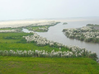
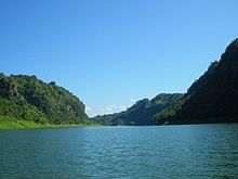
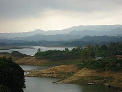
Sundarban is the world biggest mangrove forest. In Bangladesh tourism, Sunderban plays the most vital role. A large number of foreigners come to Bangladesh every year only to visit this unique mangrove forest. Besides, local tourists also go to visit Sundarban every year. The area of great Sundarban is approximately 6000 sq. km.

General Information about Sudarbans:


Area: Nearly 2400 sq. miles or 6000 sq. km. 

Forest Limits: North-Bagerhat, Khulna and Sathkira districts : South-Bay of Bengal; East-Baleswar (or Haringhata) river, Perojpur, Barisal district, and West-Raimangal and Hariabhanga rivers which partially form Bangladesh boundary with West Bengal in India.


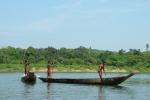
Main Attractions: Wildlife photography including photography of the famous Royal Bengal Tiger, wildlife viewing, boating inside the forest will call recordings, nature study, meeting fishermen, wood-cutters and honey-collectors, peace and tranquility in the wilderness, seeing the world's largest mangrove forest and the revering beauty.

The Sundarbans are the largest littoral mangrove belt in the world, stretching 80km (50mi) into the Bangladeshi hinterland from the coast. The forests aren't just mangrove swamps though; they include some of the last remaining stands of the mighty jungles, which once covered the Gangetic plain.

The Sundarbans cover an area of 38,500 sq km, of which about one-third is covered in water.
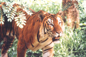
Since 1966 the Sunderbans have been a wildlife sanctuary, and it is estimated that there are now 400 Royal Bengal tigers and about 30,000 spotted deer in the area.
Sundarbans is home to many different species of birds, mammals, insects, reptiles and fishes. Over 120 species of fish and over 260 species of birds
have been recorded in the Sundarbans. 
The Gangetic River Dolphin (Platanista gangeticus) is common in the rivers. No less than 50 species of reptiles and eight species of amphibians are known to occur. The Sundarbans now support the only population of the Estuarine, or Salt-Water Crocodile (Crocodiles paresis) in Bangladesh, and that population is estimated at less than two hundred individuals

Here land and water meet in many novel fashions, Wildlife presents many a spectacle. No wonder, you may come across a Royal Bengal Tiger swimming across the streams or the crocodiles basking on the riverbanks.

Thursday, February 07, 2013

Kuakata


Kuakata, locally known as Sagar Kannya (Daughter of the Sea) is a rare attractive beauty spot on the southernmost tip of Bangladesh. Kuakata in Latachapli union below Kalapara Police Station of Patuakhali district is about 30 km in length and 6 km in breadth. It is 70 km from Patuakhali district headquarters and 320 km from Dhaka.


At Kuakata brilliant amalgamation of the picturesque natural beauty, sandy beach, blue sky, vast expanse of water of the Bay and evergreen forest in really eye-catching. From its seashore you can watch both sunrise and sunset. The coconut trees increase the scenic beauty of this beach.


The main tourist period is in winter but all over the year tourists visit this place. In Kuaka you can visit the life style of tribe Rakhains, who are very friendly to the tourist and guests.


You can visit Buddhist Temple where you can see the sculpture of Goutom Buddha and two wells of 200 years old. restricted name of the well is Kua and Kata is a local name of digging a well; so was the name Kuakata. Fisherman village is another place where you can visit and observe the lifestyle of the Fisherman.


Shopnopuri


Shopnopuri is one of the most beautiful artificial tourist spot in North Bengal. You can go there either from Hili or from Dinajpur. There you can enjoy your full day watching this artificial beauty.You can spend night also In Shoponopuri rest house but for that you will have to book in advance. It is an idle Picnic spot also where lots of picnic parties come every year

Khagrachari


266 km by road from Dhaka and 112 km from Chittagong.  The district of Khagrachhari represents the natural, wild, beauty of Bangladesh. Khagrachhari District is under Chittagong division with an area of 2699.55 sq km, is bounded by the Indian State of Tripura on the north, Rangamati  and Chittagong districts on the south, Rangamati district on the east, Chittagong district and the Indian State of Tripura on the west. Annual average temperature: maximum 34.6ºC, minimum 13ºC; annual rainfall 3031 mm. The hills of this region are composed of folded sedimentary rocks. Notable hill ranges Alu Tila, Bhanga Mura (416.66 m), Matai Pukhiri (213.36m), Matai Lakho (274.32 m); main rivers are Chingri, Maini, Feni and Halda; lake Mataipukhiri (Debotar pukur).


Major Tourist Spots in Khagrachhari

Alutila Hill: Khagrachhari is the natural wild beauty of Bangladesh. Here you can visit the tribal lifestyle of Chakmas' in Khagrachari. You can also visit Alutila hill. Alutilla, surrounded by deep forest, has a dark cave with an inner dimension approximately 100 meters long with a hill stream flowing right through. One can see the whole Khagrachhari twon at a glance from the top of Alutilla.

Mung Rajbari: Another attraction is the Rajbari or palace of the Mogh Chief at Manichhari where tourists can see a Royal bed made of ivory.

Guimara: Besides, the forest of Guimara and the hill there are worth seeing. Other places worth visiting include the ababdoned Dighi of the Former King of Tripura.

Sharthok:  The War of Liberation Memorial Monument Sharthok’’ a Janmo’’. a budshist temple, river and canal.

Matai Pukhiri: A remarkable lake known as the Matai Pukhiri, 500 meters above ground level at Nunchhari. According to a legend of the Tripura tribe, the water of this lake never dries up nor becomes dirty, which is why it is called Matai Pukhiri or the Lake of God

Rangamati


Rangamati(Bengali: রাঙ্গামাটি) is the Administrative Headquarter of Rangamati Hill District in the Chittagong Hill Tracts of Bangladesh. The town is located at 22°37'60N 92°12'0E and has an altitude of 14 metres (49 feet).


It's a travel destination of Bangladesh which is known as "Lake City".
From Chittagong a 77 km road amidst green fields and winding hills leads to Rangamati; which is a wonderful repository of scenic splendours with flora and fauna of varied descriptions. The township is located on the western bank of the Kaptai lake. Rangamati is a favourite holiday destination because of its beautiful landscape, scenic beauty, lake, colourful indigenus groups (Chakma, Marma etc.), its flora and fauna, indigenous museum, hanging bridge, homespun textile products, ivory jewellery and the indigenous men and women who fashion them. For tourists, the attractions of Rangamati are numerous. Indigenous life, fishing, speed boat cruising, hiking, bathing or merely enjoying nature as it is.

Wednesday, February 06, 2013

Nilgiri


Nil Giri is the highest hill resort of Bangladesh with amazing natural beauty. This Resort is located 47 km South-East of Bandarban town on Chimbuk Range at a height of 2400 feet from sea level. It has a high class residential accommodation that makes a difference.  This beautiful resort in the top of the mountain maintain by the Bangladesh Army.


You will be amazed when you see that the cloudy sky often kisses the peak of the hill. Gentle breeze was blowing down the hill side and thin clouds were hanging around on their way to casual fly. Dimmed through the clouds, silver moon light was rolling down the folds and slopes.  It is Imagine the scene! Clouds are playing with you and you can touch them! This is the most attractive place of Bangladesh for those who love hills and clouds.
How to go:


It is 47 KM away from Bandarban. If you get on a Bus from Dhaka at around 10 o’clock you will reach Bandarban at dawn. For better freedom one can rent a microbus or car from Dhaka. To save time you can reach Cox’s Bazaar by air for onwards move to Nilgiri by bus or rent a car. You have to stay at Bandarban hotel and next day you can move to Nilgiri.

Accommodation:


The accommodation in Nilgiri, in fact, makes its difference. Good hotels are there at Bandarban city too. Accommodation and food for 3 days will cost near tk 10000. Conveyance will depend on means you choose from tk 7000 minimum to maximum tk 11000 if you go by plane to Chittagong. Army man can get special priority for the lodge and cottages. But if it is not booked by any army and the lodge may vacant any day, you can reserve it. But it is so scarce happening. Most of the time Nilgiri remains booked. So try to contact the authority before three month to stay here. The tent is ready for you for short notice but you know it is a busy tourist’s spot. So book this before you get there.

Food Stuff:


Nilgiri is mainly a rest house. It has a clean and healthy restaurant. So don’t worry about stomach! Rice, beef, mutton are prepared in bamboo without water is really mouth-watering. Every meal cost is about 200-500 BDT. They can provide various types of taste food.


Contact Number of Nilgiri:  01190811322, 01925882338